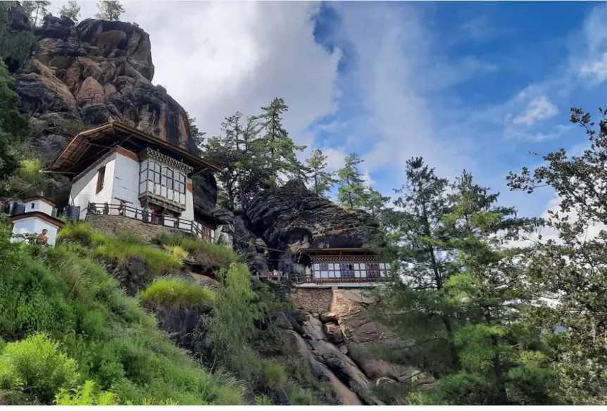
The Singye Dra Hike leads to a sacred site perched on a rocky outcrop overlooking the breathtaking Paro Valley. This revered location is the abode of Khandro Singye Dogma, the lion-faced dakini, and houses a meditation cave associated with Guru Rinpoche (Padmasambhava). The site includes two temples and several other sacred pilgrimage points, making it an important spiritual destination for Bhutanese devotees and travelers alike.
According to legend, after completing his meditation at Paro Taktsang, Guru Padmasambhava was invited by locals at Dop Shari to help subdue a pair of demons. During his stay, he meditated at the Singye Dra cave, where he is said to have encountered Khandro Singye Dogma. The site also holds a statue of Sengdongma, gifted by the Fourth King of Bhutan, representing Guru Rinpoche’s wrathful emanation, which is believed to protect against obstacles, negative spirits, and black magic.
Historically, the original temple was destroyed by fire and later rebuilt under the guidance of Royal Mother Ashi Sangay Choden Wangchuck. The name Singye Dra—meaning “Lion’s Rock”—originates from a trulku’s vision of a lion-shaped rock at the site, reflecting the temple’s spiritual energy and strength.
It is a short hike but rewarding, taking about 30 minutes from the road end. The trail ascends gently through forested slopes before reaching the temple, offering stunning views of the Paro Valley along the way. Today, the site is maintained by the Zhung Dratshang, ensuring its preservation as a place of meditation, pilgrimage, and spiritual reflection.
Difficulty Level: Easy
Duration: 30–40 minutes uphill from the road end
Altitude: Approx. 2,300–2,400 meters
Highlights: Sacred meditation cave, Khandro Singye Dogma, Sengdongma statue, panoramic views of Paro Valley, and spiritually significant pilgrimage site.
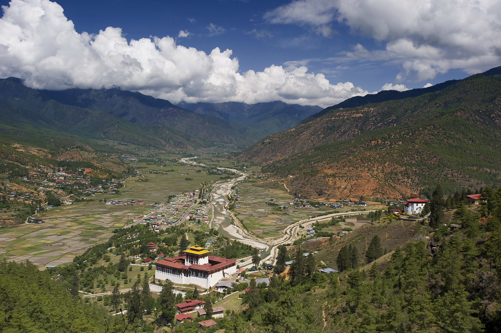
The Zuri Dzong Hike is one of the most scenic and accessible day hikes in Paro, offering a gentle climb through lush forests, rolling slopes, and panoramic valley views. Starting about 2 km from Ta Dzong, the trail winds through verdant greenery, past cloud-kissed mountains, and small local settlements, creating a journey that feels both serene and magical. Along the way, hikers are treated to sweeping vistas of the Paro Valley, making it a favorite spot for photography and nature lovers.
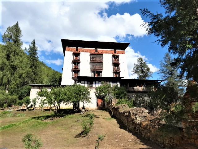
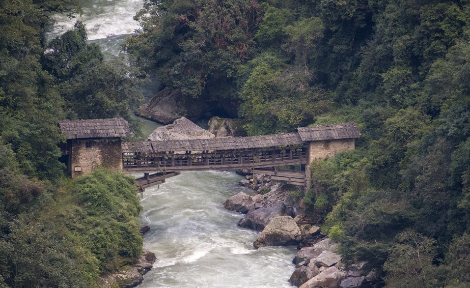
The trail leads to Zuri Dzong, a historic fortress built in 1352, believed to be the oldest Dzong in Bhutan. This six-story fort stands like a sentinel over the valley, surrounded by majestic cypress trees, some over 400 years old. Local legend tells of a villager who was tasked with rolling timber for Paro Dzong construction; when paused for tea in Zuri’s courtyard, the cypress trees planted themselves there, giving rise to the monastery’s iconic grove. The Dzong’s thick walls, narrow arrow slits, and elevated storage floors reveal its strategic importance in defending the valley centuries ago. Inside, the monastery exudes a tranquil, ethereal atmosphere, making it a place for reflection and spiritual respite.
Hikers also encounter a charming stream with a narrow bridge and glimpses of the surrounding cliffs, adding a sense of adventure to the gentle trek. The forested path is rich with flora and fauna, and the constant interplay of clouds and sunlight over the valley enhances the hike’s fairytale-like feel. The hike is easy, taking roughly 30–60 minutes uphill, making it suitable for travelers of all ages and fitness levels. After exploring Zuri Dzong and resting under the ancient cypress trees, visitors can retrace their steps along the same trail, leaving with both a sense of accomplishment and inner calm.
For those who prefer a short, peaceful hike with incredible views, cultural depth, and a touch of Bhutanese mythology, the Zuri Dzong trail offers an unforgettable experience—a perfect blend of nature, history, and spiritual serenity.
Duration: 1–2 hours round trip
Altitude: 2,250 m – 2,400 m
Difficulty Level: Easy
Highlights: Panoramic Paro Valley views, Zuri Dzong fortress, ancient cypress trees, narrow stream bridge, lush forest, cloud-covered mountains, and tranquil monastery experience.
Other Notes: Ideal for photography, short day hike, and a serene introduction to Bhutanese history and culture.
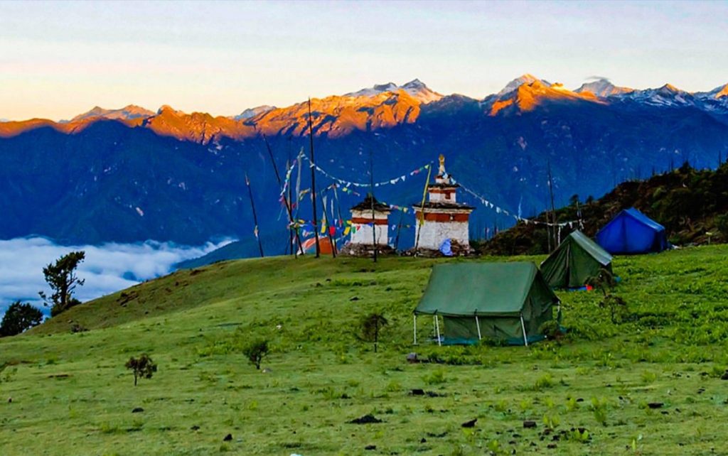
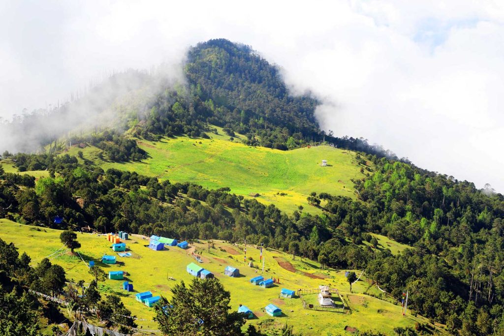
Perched high in the Himalayas, the Bumdra Trek offers a journey through breathtaking landscapes and Bhutanese spiritual heritage. Legend has it that over 800 years ago, a hundred thousand celestial beings left their footprints on a sacred rock here. Today, travelers can follow this mystical trail on foot, accompanied by horses, yaks, and experienced guides, to immerse themselves in Bhutan’s rich traditions and natural beauty at altitudes reaching 3,800 meters.
One can also hike to Namgong La Sky Burial, which is a steep but manageable trail that takes approximately 40 minutes. The path winds through alpine forests and open meadows, offering serene views of the surrounding mountains and valleys. Along the way, trekkers can enjoy the peaceful atmosphere and glimpses of local flora and birdlife. Upon reaching Namgong La, visitors are greeted with a striking and culturally significant site, where traditional Bhutanese sky burial rituals are performed, providing a unique insight into the country’s spiritual traditions and connection with nature. The viewpoint also offers sweeping vistas of the Paro Valley, making the hike both a spiritual and scenic experience.
This two-day trek is an ideal blend of adventure, spirituality, and scenic exploration, making it one of Bhutan’s most iconic hikes.
Trek Highlights
1. Duration and Route
The trek begins at Sang Choekor Monastery, where trekkers pay respects at the Buddhist college before starting the ascent. The route climbs steadily through thick alpine forests of pine and rhododendron for about 3 hours, reaching the base of the historic Bumdra Monastery. The final stretch involves a steep but rewarding pull through ruins and fluttering prayer flags to the hilltop temple, offering panoramic views of Paro Valley and the airport below.
The descent follows a serene forest trail for around 40 minutes, emerging onto a high meadow adorned with sacred chortens and prayer flags, completing the trek’s spiritual and scenic journey.
2. Altitude
The trek starts at approximately 2,400 meters and climbs to 3,800 meters at the Bumdra Monastery, giving trekkers spectacular views of the surrounding mountains, valleys, and Paro town below.
3. Difficulty Level
Rated as hard, the trek requires a reasonable level of fitness. While yaks and horses carry most of the luggage, hikers need to manage a personal backpack during steep climbs and uneven terrain. The first day involves a rigorous ascent, while the second day combines a moderate descent through meadows and forested paths, making the trek accessible to most physically prepared travelers.
4. Scenic Beauty
The trail winds through dense forests, wildflower meadows, and alpine ridges, offering ever-changing views of the Himalayan peaks. The forests are alive with birdsong and, in spring, colorful rhododendron blooms create a spectacular backdrop.
5. Spiritual Significance
The trek’s spiritual centerpiece is the Bumdra Monastery, a remote site steeped in legend and history. The trail also provides an opportunity to visit Taktsang Monastery, famously known as the Tiger’s Nest, one of Bhutan’s holiest sites. Along the route, small stupas and sacred markers punctuate the trail, reflecting Bhutan’s deep connection between nature and spirituality.
6. Experience
Travelers can enjoy moments of meditation, photography, and quiet reflection, punctuated by the melodic sound of birds and the breeze over the valley. The trek offers a unique combination of adventure, cultural immersion, and panoramic Himalayan vistas, making it a quintessential Bhutan experience.
Trek Details
Drive from Thimphu toward Hongtsho Village, a small settlement located along the Thimphu to punakha highway. From Hongtsho, continue on a side road for about 10 km to reach Tashigang Lhakhang, a beautiful monastery perched on a ridge at an altitude of around 3,300 meters overlooking the surrounding valleys.
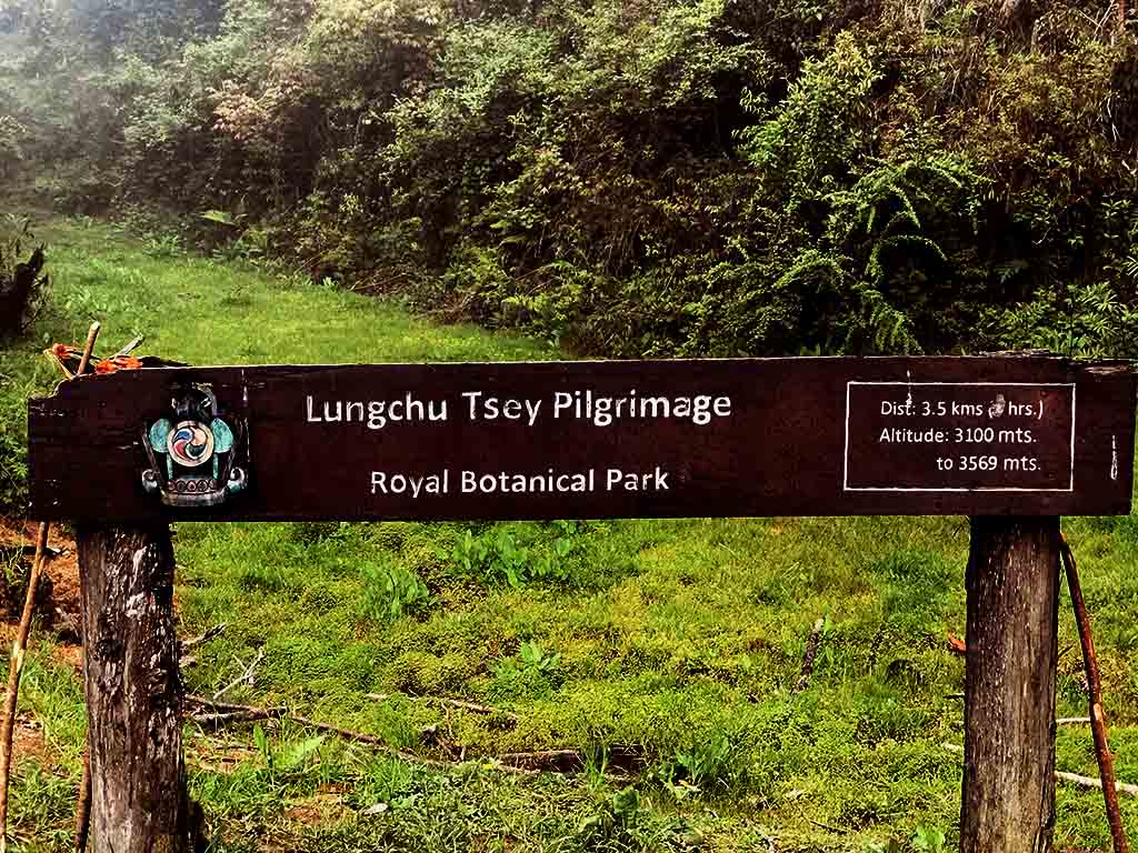
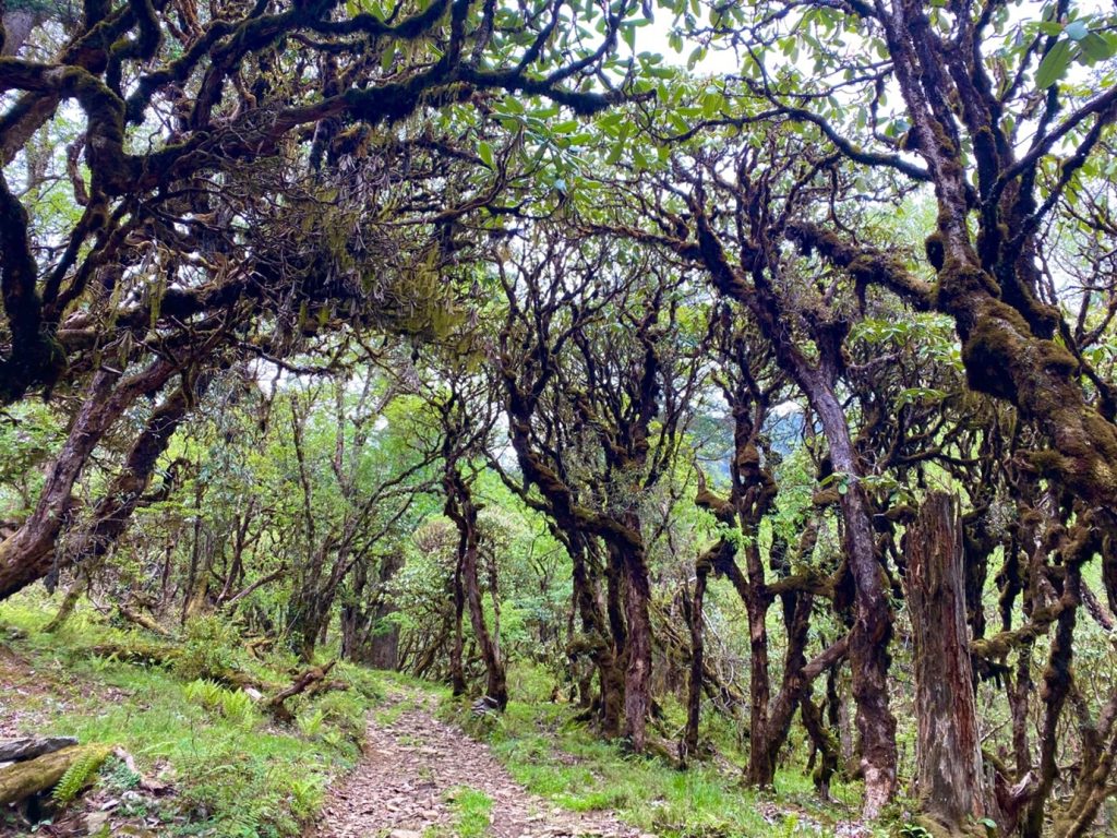
After a short visit to the monastery, begin the hike toward Lungchutse Lhakhang, one of the most scenic day hikes in western Bhutan. The trail passes through peaceful forests dominated by hemlock, rhododendron, and high-altitude Himalayan vegetation. During spring, the rhododendron forests bloom in vibrant colors, making the trail especially beautiful.
The hike gradually ascends through dense forests filled with towering trees, wildflowers, and occasional sightings of Himalayan birds. The quiet natural surroundings make this hike particularly enjoyable for nature lovers and those seeking a tranquil experience in Bhutan’s pristine mountain environment.
After approximately 1.5–2 hours of hiking, you will reach Lungchutse Lhakhang, a small temple located on a ridge at about 3,560 meters. From the summit, visitors are rewarded with spectacular 360-degree panoramic views of the Himalayan mountain range on clear days, along with sweeping views of the valleys and forests below. Prayer flags flutter across the ridge, creating a peaceful and spiritual atmosphere.
After spending time enjoying the views and exploring the temple, retrace the trail back to Tashigang Lhakhang, where the vehicle will be waiting. From there, drive back toward Hongtsho and continue to visit Ser Bhum Brewery, Bhutan’s first craft brewery, where you can relax and taste locally brewed beer made using Himalayan spring water and traditional brewing techniques.
This excursion offers a wonderful combination of nature, culture, and panoramic Himalayan scenery, making it one of the most rewarding day hikes near Thimphu.
Difficulty Level: Moderate
Hiking Duration: Approximately 3–4 hours (round trip)
Altitude Range: 3,300 m – 3,560 m
Highlights: Rhododendron and hemlock forests, mountain ridge views, Lungchutse temple, Himalayan panorama, and visit to Ser Bhum Brewery.
Take a drive through the scenic countryside of Punakha Valley toward the trailhead near Khamsum Yulley Namgyal Chorten. From here, a diversion route leads to one of Punakha’s lesser-known but rewarding hiking routes the trail to Jiligang Lhakhang.
The hike begins by crossing a suspension bridge over the Mo Chhu (often referred to locally as the “Female River”). As you walk across the gently swaying bridge, the cool breeze from the glacial river below and the sound of rushing water provide the first glimpse of the natural beauty that awaits on the trail.
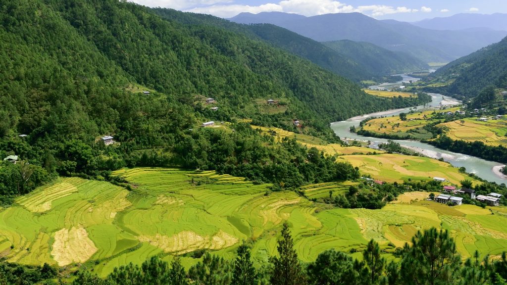
From the bridge, the path gradually climbs through terraced paddy fields, traditional farmland, and shaded pine forests. The moderately strenuous hike takes you through peaceful rural landscapes where the environment remains largely untouched. Along the way, hikers are rewarded with occasional panoramic views of the valley below, including distant glimpses of the magnificent Punakha Dzong, one of Bhutan’s most important historical fortresses.
As you ascend further, the trail passes through quiet farmlands and small settlements where you may have the opportunity to visit a traditional Bhutanese farmhouse, observe rural life, and interact with local villagers. During the summer months, the forests and riverbanks are alive with birdlife, and visitors may spot several species of Himalayan birds that inhabit the region.
The steady climb eventually leads to the hilltop Jiligang Lhakhang, a serene monastery perched high above the valley. The peaceful surroundings and the sight of the monastery appearing on the ridge provide a welcome reward after the hike.
According to local legend, the monastery is closely connected to the famous Bhutanese saint Drukpa Kunley, also known as the Divine Madman. It is said that his brother, Lama Ngawang Chogyal, once demonstrated his spiritual powers by throwing a cat from a hilltop at nearby Sonagasa in the valley below. Miraculously, the cat reappeared unharmed through a hollow tree near the present location of the monastery. Because of this event, the site was named Jiligang, meaning “Cat’s Peak.” Impressed by the miracle, Drukpa Kunley later established the monastery at this location in the 15th century.
From the hilltop monastery, visitors are rewarded with spectacular 360-degree views of the surrounding mountains, valleys, and nearby villages, traditionally said to include views of nine surrounding villages. On clear days, distant snow-capped Himalayan peaks can also be seen.
Jiligang Lhakhang is also believed to hold similar blessings associated with fertility as the nearby Chimi Lhakhang, another sacred site linked to Drukpa Kunley. Visitors can spend time exploring the monastery, enjoying the peaceful atmosphere, and interacting with the caretaker family who maintain the temple and warmly welcome travelers.
This hike offers a perfect combination of nature, cultural interaction, spiritual heritage, and panoramic Himalayan scenery, making it one of the most memorable experiences in the Punakha region.
Difficulty Level: Moderate to Strenuous
Hiking Duration: Approximately 6–7 hours (round trip)
Highlights: Suspension bridge crossing, pine forests, terraced rice fields, village life, views of Punakha Dzong, Himalayan birdlife, and the hilltop Jiligang Lhakhang with panoramic mountain views.
From Pele La Pass, which sits at an altitude of about 3,420 meters, you begin a beautiful and culturally rich hike toward Rukubji Village. Pele La Pass is traditionally considered the natural boundary between western and central Bhutan and offers sweeping views of alpine meadows, dense forests, and distant Himalayan ridges.
The trail you follow is part of the historic Trans Bhutan Trail, a centuries-old route that once served as the main pathway connecting eastern and western Bhutan. In earlier times, traders, monks, messengers, and travelers used this trail to move between villages and dzongs across the kingdom. Today, it has been restored as a cultural trekking route, allowing visitors to experience Bhutan’s landscapes and traditional way of life.
The hike begins with a gentle descent from Pele La Pass through open alpine meadows often used as grazing grounds for yaks and cattle. The air here is crisp and cool, and on clear days the surrounding mountains and valleys provide spectacular views. As you continue, the trail gradually leads into peaceful forests of blue pine, fir, and rhododendron, which bloom beautifully during the spring season.
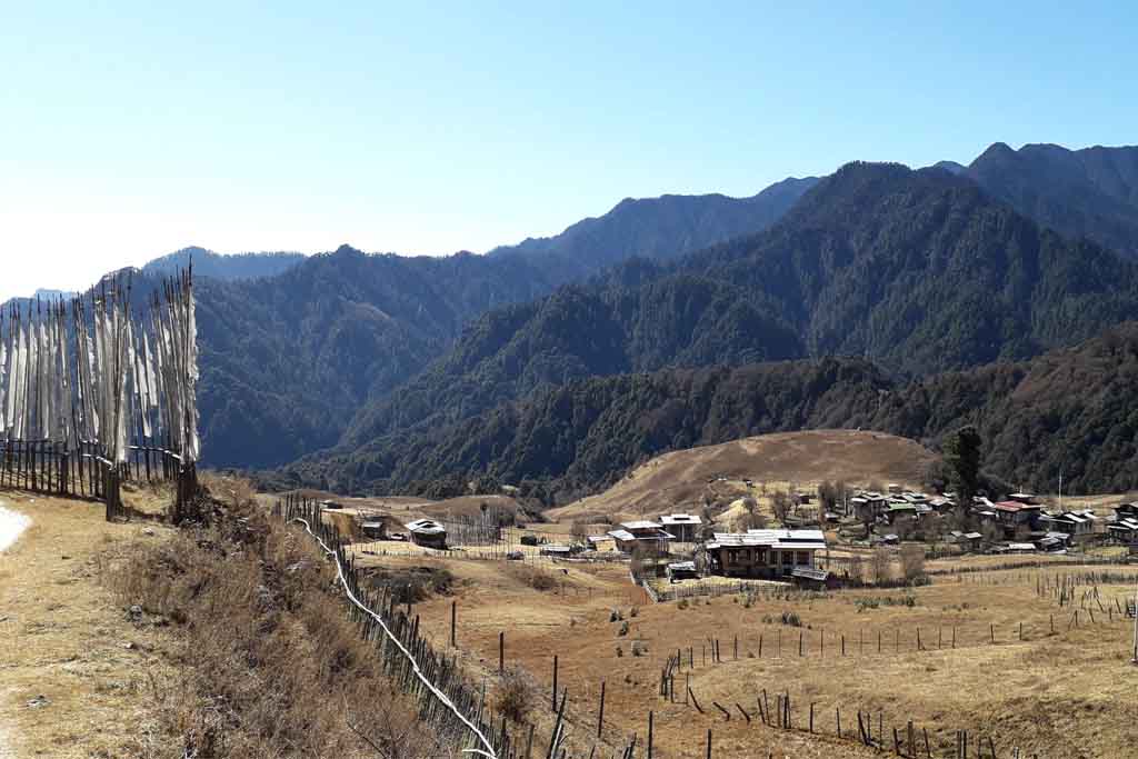
Further along the trail, you begin to encounter small clusters of traditional Bhutanese farmhouses, prayer flags, and chortens (Buddhist stupas), reflecting the spiritual culture deeply rooted in rural Bhutan. The path passes through Rukubji Village, a charming highland settlement known for its distinctive traditional architecture, stone houses, and terraced fields. The village is home to a small community of farmers and yak herders who maintain a lifestyle closely connected to nature and tradition.
Hikers can choose to end the walk at Rukubji Village, where a vehicle may be arranged for pickup. However, those wishing to continue can extend the hike further along the valley toward the picturesque Chendebji Chorten. This striking white stupa, built in the 19th century by Lama Shida from Tibet, was constructed in the style of the famous Boudhanath Stupa in Nepal. According to local belief, the chorten was built to subdue a powerful spirit that once inhabited the area.
The hike offers a perfect combination of natural beauty, cultural encounters, and historical significance, making it one of the most rewarding walking experiences in central Bhutan.
Difficulty Level: Moderate
Walking Time: Approximately 3–4 hours, depending on the endpoint
Highlights: Pele La Pass landscapes, Trans Bhutan Trail heritage, traditional Rukubji village life, alpine meadows, yak pastures, and the historic Chendebji Chorten.
Before the construction of Bhutan’s East–West Highway, Trongsa Dzong served as the main gateway connecting western, eastern, and southern Bhutan. Travelers, traders, and monks once used an ancient trail—now known as the Old Route Hike—to access the dzong from the valley below.
This historic trail begins near the viewpoint overlooking Trongsa Dzong and descends toward the Mangde Chhu, the river flowing through the valley beneath the town. In the past, travelers crossed the river using a traditional Ba Zam, a wooden cantilever bridge built using ancient Bhutanese engineering techniques. Although the original bridge was once washed away by the river, it has since been rebuilt to preserve the historical route and improve access for locals and visitors.
Today, the trail is known as the Mangde Foot Trail, a scenic and culturally rich hiking route that follows sections of the Mangde River and winds through lush Himalayan forests of pine and rhododendron. Along the way, hikers enjoy beautiful views of the surrounding mountains and valleys while passing small rural settlements where traditional Bhutanese life continues much as it has for generations.
The trail also features several cultural landmarks, including small chortens (Buddhist stupas), prayer flags, and traditional cantilever bridges that reflect Bhutan’s architectural heritage.
The hike concludes with a gradual climb back toward the majestic Trongsa Dzong, one of Bhutan’s largest and most historically important fortresses. Perched dramatically on a ridge overlooking the valley, the dzong once controlled the strategic trade routes between east and west Bhutan.
This moderate hike offers a unique opportunity to experience Bhutan’s natural beauty while connecting with the country’s history, culture, and traditional village life.
Difficulty Level: Moderate
Walking Time: Approximately 1.5–2.5 hours
Highlights: Panoramic views of Trongsa Dzong, Mangde River valley, traditional wooden cantilever bridge, forests, and rural villages.
Longtey Hike, one of the most beautiful nature trails in the Phobjikha Valley. The starting point is located in Longtey Village, approximately a 30-minute drive from Gangtey along the East–West Highway near Pele La Pass.
The hike begins by descending gently along a trail to the right side of the road. The path gradually leads through thick bush bamboo vegetation before reaching a small cluster of traditional farmhouses. This quiet area is surrounded by dense forests and open grazing land.
As you continue along the trail, the landscape opens into beautiful valleys lined with vibrant rhododendron forests, which bloom spectacularly during spring. In the colder months, the meadows are often dotted with grazing yaks belonging to local herders, adding to the unique Himalayan atmosphere.
The trail then gradually climbs through ancient old-growth rhododendron forests, creating a mystical environment with towering trees and moss-covered ground. This section involves a slightly steeper uphill walk as you approach a ridge pass.
From the pass, hikers are rewarded with stunning panoramic views overlooking the valley below, including the historic Gangtey Monastery, the monastic college (Shedra), surrounding villages, and the wide glacial floor of Phobjikha Valley.
After enjoying the views, the trail gently descends toward the peaceful Kumbu Village, a small and idyllic settlement known for its traditional Bhutanese houses and farmlands.
From Kumbu village, guests may either:
Hike Information
Difficulty Level: Moderate
Duration: Approximately 4 hours
Highlights: Longtey Village, rhododendron forests, yak grazing meadows, panoramic views of Gangtey Monastery, and traditional Kumbu Village.
In 1972, Bhutan’s visionary Fourth King, Jigme Singye Wangchuck, gave the world a new way to think about progress. He believed that measuring a country only by money and production missed what truly matters, the happiness of its people. And so, the idea of Gross National Happiness (GNH) was born.
Unlike GDP, which counts economic output, GNH asks a deeper question: Are people living meaningful, balanced, and joyful lives?
Modern life often links happiness to wealth and possessions. But such pleasures are temporary. In Bhutan, happiness is rooted in inner peace, family bonds, community connection, cultural identity, and living in harmony with nature.
This philosophy shapes national policies, ensuring development never comes at the cost of well-being, environment, or heritage. GNH became a guiding principle of governance and was later written into the Constitution.
A Different Kind of Success
Bhutan’s approach surprised the world. In 2007, it ranked among the happiest nations despite modest economic statistics. The Bhutanese credit their contentment to strong communities, simple living, spiritual values, and close family ties.
Travelers often arrive curious and leave inspired, touched by the country’s sincerity, pristine landscapes, and living traditions.
Core Beliefs
Four Pillars
Nine Domains
Living standards, education, health, environment, community vitality, time use, psychological well-being, governance, and cultural resilience.
Bhutan’s policies align with GNH, making it one of the world’s most admired models of holistic development.
GNH reminds the world that development should nurture both prosperity and peace of mind.
Bhutan follows a unique tourism model known as “High Value, Low Volume Tourism”, designed to protect the environment, culture, and local communities. The key part of this policy is the Sustainable Development Fee (SDF), which every tourist pays based on nationality.
Below is the latest updated breakdown of Bhutan’s tourism policy, SDF fees, and visa rules.
🌿 What is the Sustainable Development Fee (SDF)?
The SDF is a daily fee charged by the Royal Government of Bhutan to support:
The fee helps Bhutan maintain sustainable tourism and avoid mass tourism impact.
💰 Latest SDF Amount for Bhutan
🌍 For International Tourists
This SDF rate is currently expected to remain valid till 2027 unless revised.
🇮🇳 SDF for Indian Tourists
Indian travelers usually enter Bhutan via permit system, and SDF is paid during permit processing.
🇧🇩 SDF for Bangladesh Tourists
This reduction supports regional tourism and strengthens Bhutan–Bangladesh relations.
✔ Visa / Permit on Arrival (Regional Countries)
They can often obtain permits at entry points (subject to conditions and queue) but they can also obtain the permit in advance which your Local tour agent based in Bhutan can help.
✔ Visa Fee
✔ Visa Required Before Travel (Other Countries)
Tourists from most countries must:
🏙 Border Town 24-Hour SDF Waiver – Important Clarification
There is often confusion about this.
✔ 24-Hour Border Town SDF Waiver & beneficiary nationality
Applies if tourists stay only within:
For Indian and Bangladesh If you leave border zone → SDF becomes mandatory.